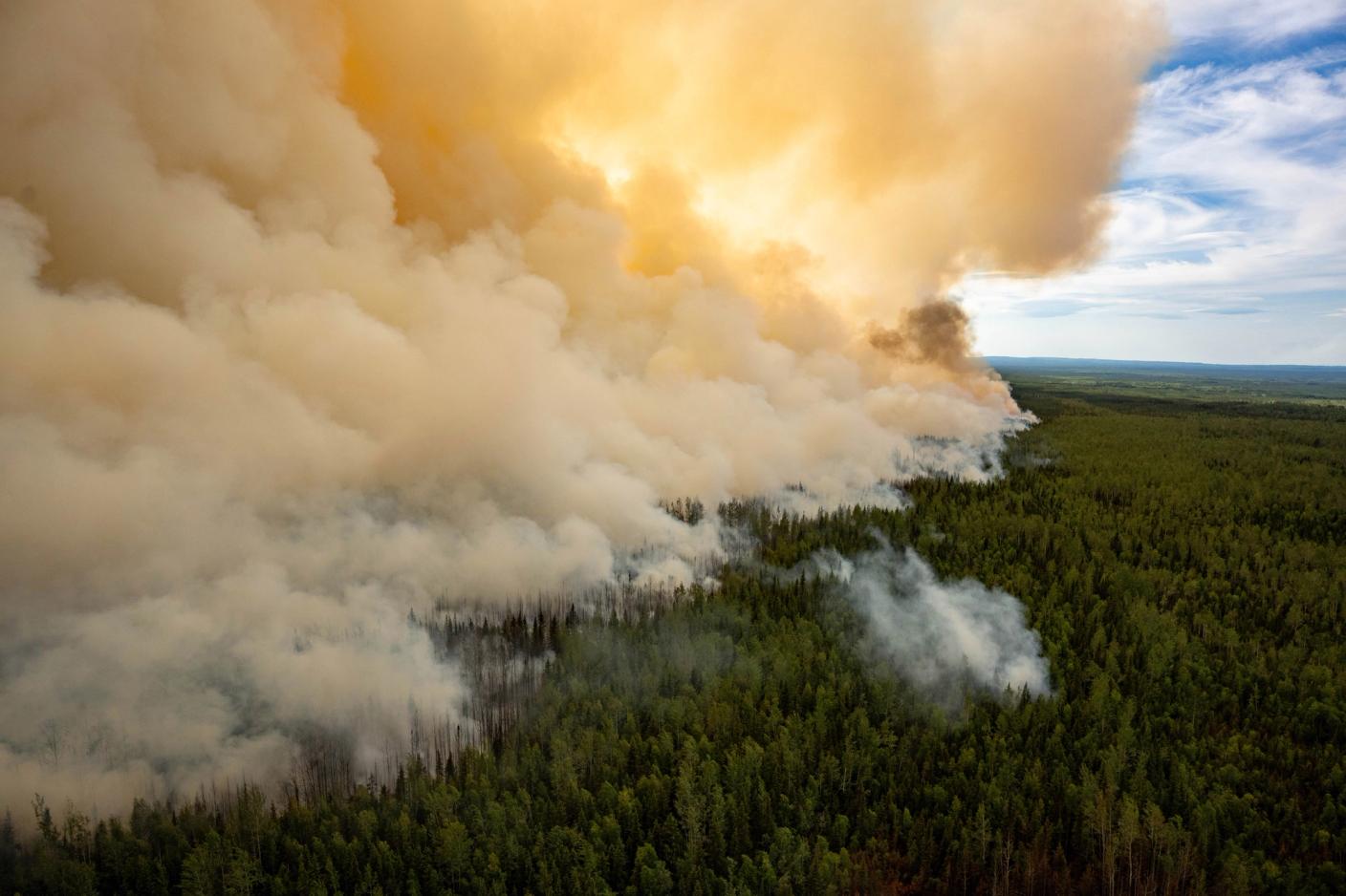
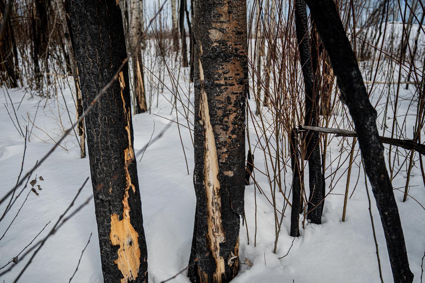
On the Sierra Yoyo Desan Road north of Fort Nelson, B.C., the trees show a leopard pattern, dark with yellow spots, on what’s left of the bark. They’ve been scorched by fire, and the mottling is everywhere. In this northeastern part of the province, nearly touching the Northwest Territories, there are reliable cycles: a boom-and-bust lumber industry, now mostly bust. Forest products company Canfor left in 2008, taking hundreds of jobs with it. Oil and gas, also boom and bust. The Cabin Gas Plant in the Horn River Basin was closed in 2024 due to low prices. But what Fort Nelson can rely on is a nearly annual boom in forest fires, including one in 2024 that threatened to burn down the town, and one last year that laid the leopard marks on these trees.
Sonja Leverkus lives in Fort Nelson. Today, when it’s minus-10 C in April, she leads a small convoy (two Super Duty Ford pickups) from the Sierra Yoyo Desan over 90 kilometres up the Komie Road, a gas company route that passes the abandoned Cabin plant, hunting for zombie fires, also called overwinter or holdover fires. Some in the “fire management community” don’t care for the Z-word. It mocks, they say, a serious issue. Leverkus shrugs. Names and terminology don’t much matter. The fires matter. She opens the truck window, then sniffs the air for the smell of smoke.
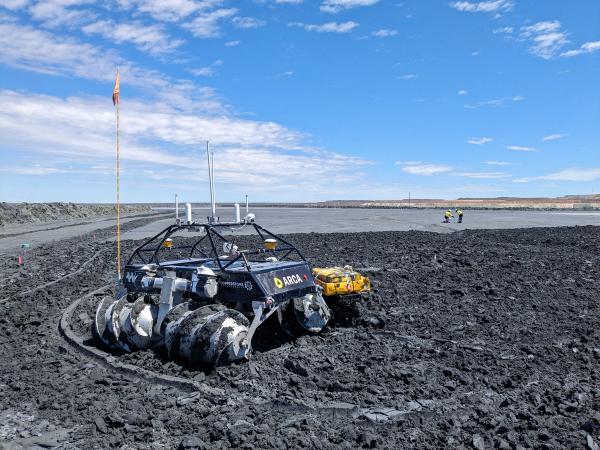
Leverkus is a wildfire specialist with a PhD in ecology and an interest in zombie fires, and an adjunct professor at the University of Alberta. She runs Northern Fire WoRx (NFWRx), a specialized company that works with the province’s wildfire service. Its arsenal runs from high-tech to decidedly low-tech: satellite imagery, thermal drones (Leverkus just got one, an EVO II Enterprise) down to shovels and a Pulaski axe for digging trenches to break a fire, and finally – arguably more reliable than AI – the human senses, smell being the most reliable, hence the open truck window.
We’re also packing a rifle in the back seat, next to Alexis Jorgensen, an ecologist and an administrator with the NFWRx team. The gun is for bears, a precaution. We pass an adult moose in the woods off the Komie (Leverkus is a moose hunter), up to its belly in snow. That’s how deep it is. This may be a good omen for 2026: a lot of snow to keep the boreal forest damp and fire-resistant come spring, although Leverkus says that with warm Chinook winds, even heavy snow can disappear before the water has a chance to sink into the ground. At kilometre 92 on the Komie, we stop. Leverkus points north. About 100 metres into leopard-spotted woods I can see smoke, just a few wisps, coming out of the snow. We’ve encountered a zombie.
“It’s kind of mind-boggling, right?” Andy Low, a senior fire specialist at another private consultancy, Forsite Consultants, told me before I flew to Fort St. John and then drove up the Alaska Highway to Fort Nelson. “We always thought of holdovers as, OK, the fire is holding over until next spring,” he said. “What Sonja is seeing is on the timescale of years.”
It’s not that it’s a new phenomenon. What’s new is the frequency, the duration and the science: there are more of them, they are lasting longer and the technology of detection is just now taking notice as climate change is making things worse.
With apologies to Low, who prefers the term “holdovers,” zombie fires are like the namesake characters in movies and TV shows: you think they’re dead and they come back. They smoulder underground through winter, usually the remains of a previous wildfire, like the white-hot coals at the bottom of a barbecue. You don’t get flames, but you can get smoke venting through ice and snow. And if the conditions are right, they can trigger new forest fires. Ecologists speak of a 30-30-30 rule: 30 degrees air temperature, 30 per cent humidity and 30 kilometres per hour of wind are the ideal conditions for wildfire, if there is an inciting incident. That could be lightning (in more than 60 per cent of all wildfires in B.C. and just under half across Canada) or some human cause like a tossed cigarette or, often, industrial equipment or sparks from a train.
Research shows 0.8 per cent of the area burned by wildfires over a 16-year study period was caused by overwintering fires, but it depends on location. Rebecca Scholten, of the Carbon and Fire Dynamics Lab at the University of California, Irvine, found that 38 per cent of the total burned area in Alaska in 2008 was caused by a single overwintering fire that came back to life. In 2025, according to the British Columbia Wildfire Service (BCWS), of 345 fires in the region covered by the Prince George Fire Centre, which includes Fort Nelson, 61 – or 18 per cent – were overwintering fires.
Get our weekly newsletter – the people, places, and ideas revealing where Canada is headed.
Last year was a bad year across the country for forest fires, no matter the cause: 8.9 million hectares burned in Canada. In Manitoba, the Canadian Red Cross registered 32,700 evacuees from 12,600 households, mostly from First Nations. Two people in Lac du Bonnet died. In May 2024, the Parker Lake fire to the southwest of Fort Nelson led to the evacuation of the town’s more than 3,000 residents, excluding firefighters like Leverkus and those members of her team who chose to stay. At the same time, another fire burned to the north: this was the result of a holdover from 2023, caused by a lightning strike, which eventually destroyed 1,708 square kilometres of forest.
The heart of a holdover fire was thought to be peat: the spongy, organic and often metres-thick base layer of boreal forest frequently covered by castaway pine needles and “duff,” or decomposing twigs and leaves, which can act as kindling for a bigger fire. This layer of peat is thickest in the boreal forest due to the climate, a kind of Goldilocks middle between the hotter south, where the organic layer is shallower and rests on dirt and rock, and the colder North, where all organic matter is sparser. Peat is often too wet to burn. But when dry, it burns with enthusiasm: in Newfoundland and Ireland, homes have used peat instead of wood for heat, for generations. It is, though, hard to put out a peat fire. It burns slowly, stubbornly, without much flame and without needing much oxygen. In 2021 in Russia, peat was reported to be burning underground in -60 C weather. Herein lies the climate problem: with a shift to warmer atmospheric temperatures and an increase in drought in the West and North, more boreal peat is drying than in previous years, creating more fuel for overwinter fires. In his book Fire Weather: The Making of a Beast, John Vaillant reports that near Fort McMurray, Alta., site of a horrific wildfire in 2016, peat bogs had been dried to a depth of 2.4 metres.
Putting out zombies is a problem: the work is heavy and calls for deep digging with front-end loaders, which don’t do well on spongy bogs (they sink). And, in any case, water has a hard time penetrating the thick matter. If the ground is frozen, it’s not going to penetrate anyway. There is some value in using biodegradable surfactants, chemicals that make water wetter, to choke them, but the science is young. “The cost and the time investment in putting out these fires,” says Jennifer Baltzer, a professor of biology and Canada Research Chair in Forests and Global Change at Wilfrid Laurier University in Waterloo, Ont., “is pretty enormous.”
It’s worth noting, too, that the word “out” in the firefighting community is ambiguous. What Leverkus was taught is that a fire is only “out” when you and your crew can military-crawl over a burnt but extinguished landscape, crushing dirt and rocks in your hands and feeling for embers, and even then, who can know for sure?
Leverkus’s history with fire goes back to her childhood. Her parents had a ranch near Head-Smashed-In-Buffalo Jump, Alta., and when she was five, they moved to the Windermere Valley of British Columbia where, one day, a helicopter landed in the hay field to let the family know there was a wildfire on their property. “The things that I remember,” she says, “are my parents trying to get our cows across creeks, working with the forest service, helicopters landing and taking off every day, and it was really dusty and smoky, and I remember looking up and seeing chunks of ash falling.” From this grew a passion for the science of wildfire, what she calls “the boreal beast that dances.” As she says, in Fort Nelson it’s a fire culture: ranchers, guides, Indigenous communities, packers – they all know and respect the burn.
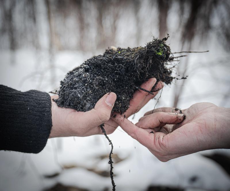
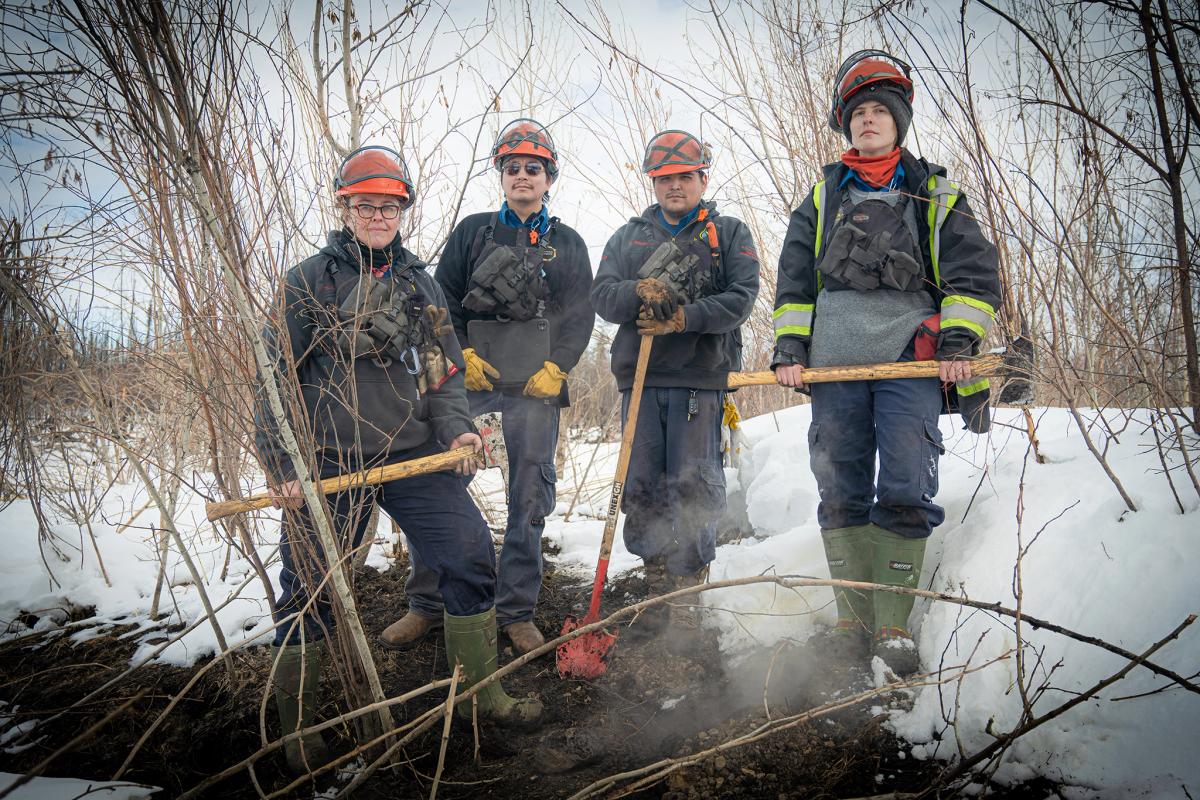
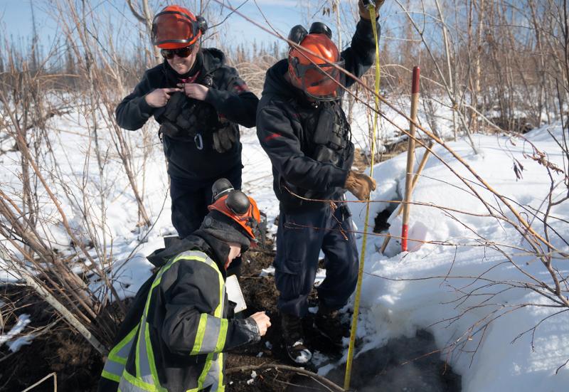
At kilometre 92 on the Komie we’re into the woods, on a deep-snow trail set by crew leaders Donovan Bertrand and David Wilmsmeier. Bertrand is a member of Acho Dene Koe, and Wilmsmeier a Prophet River First Nation member. All except me are wearing Nomex fire-retardant gear, leather gloves and orange hardhats with ear protection. For me it’s hipster urban hiking wear from MEC. Bertrand shields his mouth and nose with a black cloth. Around us are the black-and-leopard trees of last year’s burn, but there are no “danger trees” nearby, which is what wildfire specialists call ones that might fall (on wildfire specialists) when underground burning has loosened or destroyed their roots. There is a raised area in a clearing where snow has melted, revealing a layer of duff and twigs. When I step on it, I sink, but only to the height of my hiking boot’s sole. There are at least three holes emitting smoke, and there’s a vent in the snow to the immediate west, into which I put my hand and feel a steamy heat. The smell is earthy, a bit like cheap whisky mixed with animal dung. Jorgensen pulls out a young sapling to reveal charred roots, and Leverkus digs with the Pulaski to reveal clay and white coals, which she picks up. She whoops when coals get through the holes in one of her gloves, scorching her hand.
The burned root is consistent with work done by Baltzer. In a paper published last year, she and a group of scientists, including Sander Veraverbeke and Thomas Hessilt in Europe, studied 20 overwinter fires in the Northwest Territories and Alaska using Hessilt’s refined data from satellite imagery. Finding an overwinter fire is extremely challenging: it’s possible to see smoke from an airplane or helicopter if you’re lucky, but not if the smoke is sparse, and even thermal drones can’t see heat under snow. So Hessilt and Veraverbeke devised an algorithm that assigned values to high-resolution pictures from a satellite called Landsat, a series of satellite missions managed by NASA and the U.S. geological survey, in order to detect holdover fires. For her part, Baltzer took to a helicopter and visited those spots (conditions permitting) to see what she could find.
What she found: burning in tree roots and trunks, evidence of overwinter fires not just in peatlands but also in upland forests of the North, in the trees themselves. This is consistent with what we saw off Komie Road: the burned tree roots and the coals.
“It seems like it can happen anywhere on the landscape,” says Baltzer. “This is surprising.” She also found that overwinter fires were caused not by hotspots deep inside formerly raging forest fires but, instead, by fire on the perimeter, a crucial detail: if overwinter fires turn up in the middle of a burned forest, you wouldn’t expect them to cause much grief since they’d be surrounded by spent fuel. Nothing to burn. But at the edges, there are fresh trees to light up. This would tell fire management crews where they’d most likely find zombies.
The BC Wildfire Service says the Prince George Fire Centre (which covers northeastern B.C. up to up to the Northwest Territories border, including Fort Nelson and where we found the Komie fire) went into the 2025 winter with 20 overwintering fires: one in Dawson Creek, six near Fort St. John and 13 near Fort Nelson. Though by April it declared all overwintering fires were “out,” a spokesperson for BCWS says that “we assume overwintering fires could exist within the perimeter of any wildfire that was not fully extinguished in the previous season.” The province uses satellite and aircraft-based remote sensors to map overwinter fires, “however,” it adds, “these technologies can struggle to detect deep smouldering fires, especially when covered by snow and frozen ground.” Its predictions are based on soil sampling: is it wet? How wet? “The drought in the northeast,” they say, “has significantly improved since last year, thanks to the abundance of precipitation east of the Rocky Mountain Range.” Drought is comparatively worse in Dawson Creek, Vanderhoof and Fort St. James. The BCWS will be back to thermal scanning once the snow clears. In early April that snow, north of Fort Nelson, was still moose-deep.
I asked Mayor Rob Fraser of Fort Nelson about the provincial strategy. “Our community has asked the province to action these overwintering fires,” he wrote. “Our hope was that the wildfire service could see the fires and extinguish them on the spot. This proved to be only moderately successful.” Finding them is a problem, he admits, due to snow and the huge perimeter of last year’s fires. “Most people believe the BC Wildfire Service and the local contractors made an honest effort,” but he wanted more staff on the scene earlier in the year, before overwinters sparked their own new wildfires. “The province has responded to this request and our fire centre has been opening earlier in the season.”
More detection data would help, but there’s been a massive setback. The Canadian Space Agency was booked to launch WildFireSat in 2029, a non-commercial program of seven micro-satellites to track wildfires in near-real time, through a $72-million contract for U.S.-based Spire Global – which has a branch in Cambridge, Ont., where most of the assembly was to happen. In April the Government of Canada cancelled the contract with Spire, “for convenience,” meaning no one’s at fault: Ottawa just wants out. The Canada Space Agency says it “remains committed to delivering wildfire monitoring capability from space by 2029.”
In the meantime, there are other international satellites which use infrared tracking, available to Canadian wildfire managers and researchers, but they don’t have the same tight focus that WildFireSat would’ve had on the North, the boreal belt of the Canadian West and the vulnerable forests of Atlantic Canada. Still, the Canadian Wildland Fire Information System, an online dashboard, updates information every three hours during fire season using satellite data. And despite the available technology, when it comes to early detection, there’s still a place for opening the truck window and taking a sniff.